
|
An Incisive Study |
|
|
|
How do streams cut through bedrock? An elegant experiment opens the enigma.
How exactly does a stream erode into bedrock? Insights into this basic geologic question have come from an experiment so ingeniously simple, you have to wonder why no one did it before.
The apparatus is described by Leonard Sklar and William Dietrich of the University of California at Berkeley in the December 2001 Geology. They bolted disks of stone 20 centimeters across to the bottom of cylinders, filled the cylinders with water plus some sediment, then stirred them with propellors. As the water spun, the sediment grains wore down the stones, which were weighed to determine the amount of erosion.
Sklar and Dietrich explored this simple model of a rocky streambed to tease out the different roles of four different variables.
First, they tested "bedrocks" of different strengths ranging from a weathered
sandstone to a tough quartzite. They even used artificial rocks for some intermediate strengths. The result was a simple law: erosion varies inversely as the square of the rock strength.Second, they tested different sediment materials. It turned out that the square law of erosion holds true whether the sediment was the same material as the bedrock or something harder. These two findings are useful in the field and in the lab, Sklar and Dietrich say. For example, erosion rates in real streams can be studied simply by doing strength tests on the local types of bedrock.
Third, they tested different amounts of sediment. Sediment grains do their work by bouncing along the bottom and chipping at the bedrock. As long as the grains were free to move in the experimental cylinders, more sediment meant more erosion, up to a certain maximum point. (Sklar and Dietrich confirmed all this using a transparent cylinder.) But above about 150 grams, sediment started to cover the bottom in a protecting layer. Around 800 grams, erosion stopped.
Fourth, they tested different sediment grain sizes. The experimenters used 70 grams of sediment in all cases, whether it was 0.7-mm sand (about 3000 grains), 6-mm gravel (150 grains), or one 35-mm pebble (the biggest the apparatus could move). The pebble was the best eroder, and the fine sand did almost nothing. All four tests yielded graphs of data that look pretty good for such a crude experiment with natural materials.
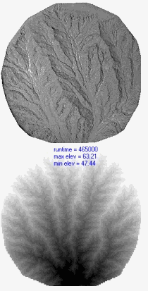
Erosion models. The experimental basin (top), about a meter across, uses silica silt with a dash of clay; a fine mist simulates rainfall and a small gate is the outlet for the resulting streamlets. It tests numerical models like the one at bottom. Images courtesy of
Les Hasbargen, University of Minnesota.There's a lot to like about this piece of research. Not least, it can be easily replicated, and it also makes a good student exercise. It can be used in fine-tuning or checking other more sophisticated erosion experiments. And it promises to help build a rulebook for streambed erosion that modelers can rely on as they replicate natural landscapes in their labs and computers.
The branch of Earth science dealing with landscapes is called geomorphology. It used to be a sleepy division of field geology, without much quantitative theory and hard to relate to today's breakthroughs in tectonics and economic geology. But now its leading edge is in computer models and large lab experiments (and on his Web site, researcher Les Hasbargen posts interesting examples of both, as shown here).
Modeling work always leads researchers back to the basics. And in the case of modeling stream erosion, one basic hypothesis goes back to
G. K. Gilbert in 1877. From observing streams in the Henry Mountains of Utah, Gilbert proposed that to cut through the most bedrock, a stream needs a certain moderate amount of sediment: too little leaves the stream short of chipping tools, and too much covers up the bedrock.We never had much need to test his theory in detail. But early computer models of streams calculated the bedrock incision rate from two factors: water speed, or stream power, and rock erodibility, a vague number representing all the complexities of the streambed. A number like that is a parameter, a necessary simplification. (Exploring parameters is
a key part of climate modeling, too.) Sklar and Dietrich have opened "the conceptual black box" of rock erodibility to the light of experiment.This bit of scientific progress does more than just vindicate Gilbert's antique theorizing. It's part of an ongoing
revolution in the way geologists see erosion, and it gives us more precise tools to analyze the history of a region. But most practical of all, it helps us better control human impact on river valleys. Gigantic dams, now being planned all over the world, do more than create lakesŚthey affect everything downstream. And the policymakers who permit them need better forecasts of those effects before they let the bulldozers move.